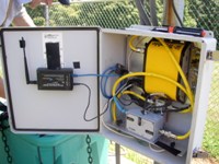
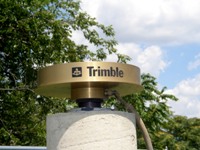
Lehigh University Mountain Top GPS Base Station (LUMT) is a solar powered station consisting of a Trimble Navigation NetRS base station receiver and a choke ring antenna. The receiver communicates with a desktop computer running Windows XP and Trimble GPS Base Software via a pair of MaxStream XEB09-C XPress Ethernet Bridge RF Modems.
What is GPS?
GPS (Global Positioning System) consists of a space segment and a control segment. The space segment consists of twenty-one Navstar satellites plus three on-orbit spares. The satellites orbit above the earth at an altitude of 10,898 nautical miles travelling around twelve-hour circular orbits. The on board controls help the satellites maintain a continuous earth seeking orientation. Twelve navigational antennas and another keep the two winglike solar arrays in a sun-seeking orientation. The control segment consists of a ground based master control station and five ground based monitor stations. The unmanned monitor stations located in Hawaii, Ascension Island, Diego Garcia, Kwjalein and Colorado Springs, pick up the signals from each satellite. From these signals a range is calculated and transmitted to the masster control station. The master control station processes this information to establish the satellite's clock correction factors and its current orbital elements. These parameters are then transmitted to each satellite at least once per day.
The United States Department of Defense developed the Global Positioning System at a cost of twelve billion dollars.
TestLinkDat
TestLinkRinex |